Except for the work of a few analysts like Carlyle Thayer, Daniel Schaeffer, and Leszek Buszynski, the role of bathymetry and submarine warfare in the Spratly Islands dispute has been largely ignored. To better understand this aspect of the dispute, it is necessary to dispel the myth of the Spratlys as an area of shallow sea, extremely dangerous for navigation and to be avoided at all costs. This perception, common before the 1920s, should have dissipated following secret missions by the colonial powers.
The British Admiralty organized several covert hydrographic missions between 1925 and 1938, meticulously mapping the area then known as the “Dangerous Ground.” In 1934 it discovered a safe sea-lane, crossing this area from north to south. The Japanese Imperial Navy also explored this maritime space from 1936 to 1938 and drew secret charts, notably of the main island, Itu Aba. The U.S Navy, based in Cavite, Philippines, also explored the Dangerous Ground, drawing its own secret bathymetric charts between 1935 and 1937 and discovering another sea-lane, crossing the area from east to west.
The Japanese commandant Unosuke Kokura, summarized perfectly, on May 1939, the gap between the civilian and military perceptions of the Spratlys:
A remarkable fact is that the whole of the Spratly islands can be considered as a kind of fortified area, because it is known as a dangerous area on all the maps of the world… But because of a laborious work of our Imperial Navy, this area is not a dangerous area at all for us. Our warships and commercial ships can sail freely through these groups of islands and take shelter behind the reefs.
The secret hydrographic research during the 1930s allowed naval authorities from different countries to understand this vast maritime territory as an archipelago crossed by secret sea-lanes. The Spratly Islands, long perceived as an area to avoid, were reinterpreted as strategic territory from which a maritime power could control the sea-lanes of the South China Sea. During the Second World War, U.S. submarines based in Australia patrolled the South China Sea and regularly crossed the Dangerous Ground using these internal sea-lanes. They also pursued scientific research around the Spratlys, notably to study layers of high density salt in the water which allowed the American submarines to escape detection by Japanese sonar.
A Nuclear Submarine in the Dangerous Ground
These secret scientific research missions were continued by U.S. forces in 1955-1956, when the United States was beginning to replace France in the Vietnam conflict. The research was so sophisticated that American nuclear submarines were able to move in the Dangerous Ground unhindered.
It is highly likely that the first traverse through the Dangerous Ground by a nuclear-powered submarine took place in April 1972. The USS Sculpin, commanded by Captain Harry Mathis, had a mission to track the movements of Vietnamese fishing boats. These boats, loaded with weapons and ammunition, were leaving China’s Hainan Island and traveling through the South China Sea to avoid the U.S. coastal blockade of Vietnam before unloading their cargoes farther south. Their routes took them through the Dangerous Ground before reaching Vietnam.
It is highly probable that the Sculpin’s journey through the Spratlys had other motivations than simply following a fishing boat used for smuggling weapons. In fact, a P-3 Orion patrol aircraft escorted the submarine. The U.S Navy would not likely have risked using a nuclear submarine for so little. It is more reasonable to imagine that the Sculpin was either tasked with collecting more scientific data on the Dangerous Ground or testing the operability of older research.
If a U.S. nuclear submarine was able to cross the Spratlys unhindered, then those of other countries could do the same. This strategic fear was expressed by the Philippine Department of National Defense in a 1982 publication:
The area has never been adequately surveyed or mapped but it is known to contain many islands, banks and reefs, shoals and cays separated by deep passages. If a hostile nation can map the area to a degree which will enable navigation of submerged ballistic missile submarines without danger of running aground, that particular nation can station Polaris type submarines in the island group and be able to control or threaten an area within a radius of 4000 km, containing a 1/3 of the world’s population, including the whole ASEAN. The area’s bathymetry makes submarine detection, hence counteraction, virtually impossible.
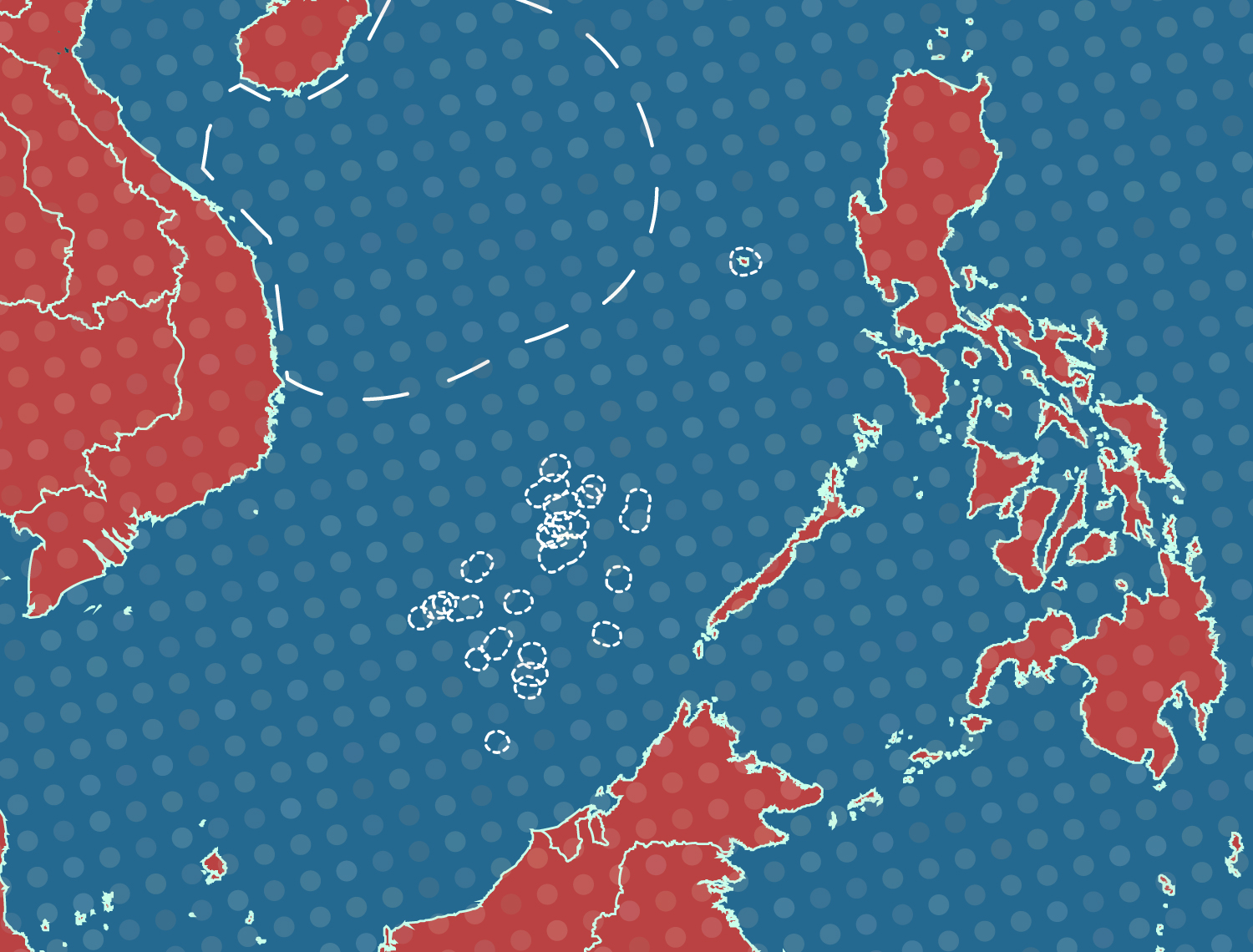
Controlling the Internal Sea-Lanes of the Dangerous Ground
The maritime space of the Dangerous Ground is structured by internal sea-lanes, with two main axes (north-south and east-west). The choice of which Spratlys to occupy seems to have followed the logic of control of these internal sea-lanes. Thus, after Taiwan occupied the main island of Itu Aba in 1956, Vietnamese forces garrisoned islands and reefs which control the western entrance of the east-west sea-lane. The Philippines, at the end of the 1960’s, favored control of the northern part of the north-south sea-lane.

China, arriving last in the Spratlys, had no choice but to take control of reefs rather than islets. By occupying Fiery Cross Reef in 1988, Chinese forces could control movements in the western part of the east-west sea-lane. And by taking control of Mischief Reef in 1995, in the heart of the Philippines’ claimed exclusive economic zone, China could monitor and even interfere with Filipino forces along the north-south sea-lane. China’s recent reclamation work allows the reinforcement of the Chinese presence along the north-south sea-lane (Gaven Reefs on Tizard Bank and Johnson South and Hughes Reefs on Union Banks) and East-West sea-lane (Cuarteron in the London Reefs).
The strategic positions of Chinese troops in the Spratlys are strong enough to blockade the resupply of the Philippines garrisons, mostly located in the northern part of the archipelago. In early 2014, Chinese boats attempted to prevent the supply of Philippine marines located on Second Thomas Shoal in the southern area. This attempt created a new situation – hampering freedom of navigation in the heart of the Spratlys.
The United States has always been neutral on the question of sovereignty within the Spratlys. However, it has consistently insisted on freedom of navigation and overflight in the area. In October 2015, the U.S Navy resumed its freedom of navigation operations near some of the features in the Dangerous Ground. These operations heighten the risk of incidents between the U.S. and Chinese navies.
Conclusion
Past activities by various navies highlighted the importance of controlling the internal maritime sea-lanes of the Spratlys. These sea-lanes have long been kept secret, though they are of crucial strategic importance. Their control would allow a maritime power to directly threaten an important part of the world. Therefore, in the wake of the July 12 ruling from the arbitral tribunal in The Hague, countries should neutralize this maritime space by guaranteeing the right of freedom of navigation and signing a denuclearization treaty for the Spratlys (as a first step before extending it to the whole South China Sea). ASEAN, among other institutions, should play a major role in this respect.
An earlier version of this article in French, “Le dangerous Ground et les Spratlys: une géopolitique des routes maritimes secrètes,” appeared in Regards Géopolitiques, Bulletin du Conseil Québécois d’études géopolitiques, Volume 2 numéro 2.