As if they were not complicated enough, the South China Sea disputes took a new turn in 2014 when China began massive land reclamation work in the region. The Philippines released photographs showing an unprecedented transformation of formerly pristine and submerged Johnson South Reef into high and dry white sand swarming with construction activity. Satellite photographs and ship tracking data by Jane’s confirmed that China’s reclamation activities extended to other features. By the end of the year, brand-new islands stood on Cuarteron, Fiery Cross, Gaven, Johnson South, and McKennan Reefs despite Philippine protests. Analysts believe Fiery Cross will be the first to host an airstrip and harbor. Most recently, Manila filed another protest over reported reclamation in Mischief Reef, located just 130 nm from the island province of Palawan. China has dismissed Philippine protests and sympathetic international reactions, initially describing the activities as intended for “improving the living and working conditions of those stationed on the islands,” arguing that the reclamation fell “within China’s sovereignty and are totally justifiable.”
There is little doubt that the China’s reclamation activities in the South China Sea are among its direct responses to the legal challenge launched by Manila. While the legal status of the contested features as described and presented in the arbitration case are not affected, their physical alteration effectively “tampers with the evidence”: the existence of the new islands will now cast doubt on whether the features were originally mere low-tide elevations or rocks above water at high tide. This makes future agreement over their nature and effect on delimitations even more difficult to reach.
For China, the artificial islands also address its own perceptions of weakness in the strategic situation at sea and appear to be attempts to guarantee itself against an adverse ruling. It aims to re-capture the high ground and pressure littoral states in the region to recognize that Beijing’s claims cannot be easily dismissed nor its interests denied.
There is no special rule in international law that specifically prohibits any state from undertaking reclamation at sea; as with any other maritime activity, its legitimacy must principally be reckoned from its location vis-à-vis adjacent land territory. While it is undoubtedly within a state’s sovereignty to reclaim land within the 12 nautical mile territorial sea, beyond that, it must be considered whether it falls within the relevant rights and jurisdictions of states expressly recognized in UNCLOS. From 12 to 200 nautical miles, insofar as reclamation is part of the establishment and use of artificial islands, installations, and structures (stationary oil rigs may be considered as artificial islands), it is governed by UNCLOS articles on the Exclusive Economic Zone and continental shelf.
Within these areas, coastal states may undertake reclamation as long as they give due notice and give due regard to the rights of all other States (UNCLOS Art. 60.3, 56.2, and 56.3). Such artificial islands, however, are clearly not entitled to maritime zones other than a 500 meter safety zone (Art. 60.5 and 60.8), and they cannot be established where they may interfere with international navigation (Art. 60.7). In the high seas beyond 200 nautical miles, all states have the freedom to establish artificial islands, installations and structures, and may not be expressly restricted by UNCLOS from reclamation activities in this respect.
To a large extent, China takes advantage of loopholes in the Philippines’ legal position. This is on account of the latter’s implicit assumption that all islands are individually entitled to only 12 nautical mile territorial seas, leaving only Palawan’s 200 nautical mile EEZ and continental shelf to reckon with in determining legal rights over Chinese-occupied features. It also exploits Manila’s concession that some of the Chinese positions are entitled at least to 12 nautical mile territorial sea zones.

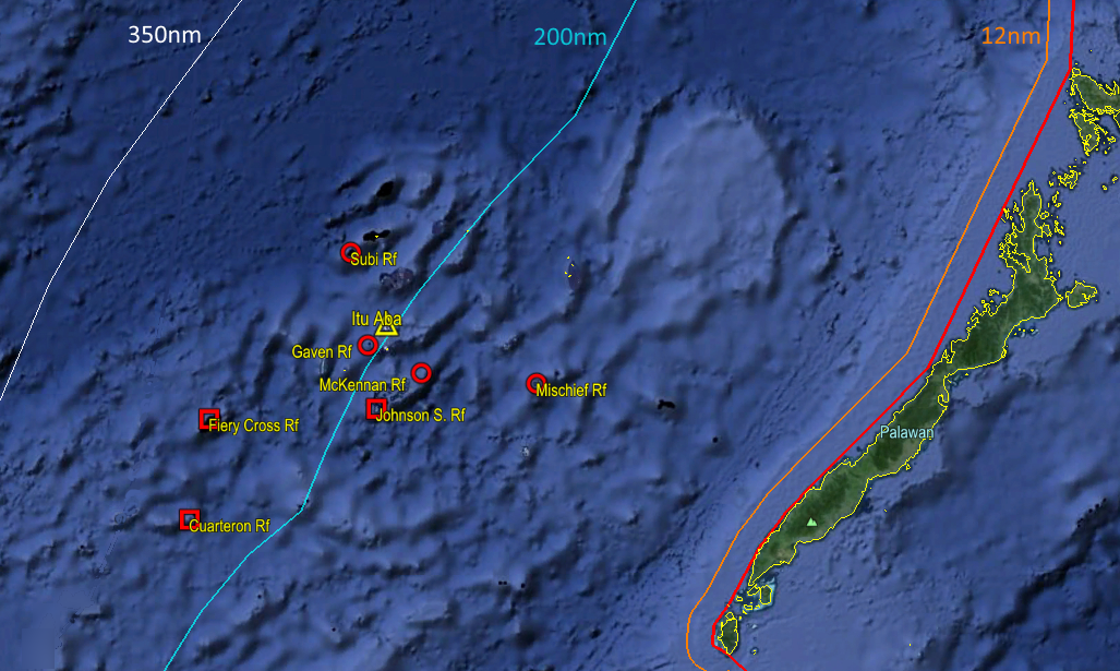
Figure 1. China’s occupied features in the Spratly Islands region, including Itu Aba under Taiwan’s control, in relation to the Philippine island of Palawan.
Based on these premises, Cuarteron, Fiery Cross, and Gaven Reefs are located in the high seas outside the Philippine 200 nautical mile zone (in the absence of an extended continental shelf claim), making it difficult to assert that any exclusive rights are adversely affected. Johnson South and Kennan Reefs are within 200 nautical miles, but possibly located within 12 nautical miles of adjacent islands or rocks under Vietnamese possession; the determination of their legality will require at least prior detailed surveys and delimitation of maritime zones with Vietnam. Only Mischief Reef stands alone far enough away from any other features above water and well within 200 nautical miles from Palawan, such that reclamation thereon could be subject to a proper legal determination. However, this may require a separate case altogether, since the reported reclamation began after the pending case was initiated.
Apart from the limitations of the Philippine case as formulated, China is also relying on its trump card in the dispute: the status and potential maritime zones of Itu Aba, held by Taiwan. If Itu Aba were to generate a full 200 nautical mile EEZ (unlikely though it may be), the median line between it and Palawan would encompass all of the Chinese-occupied features including Mischief Reef. This clearly requires maritime delimitation which is outside the scope of the arbitration case.
These do not necessarily lead to the conclusion that China’s reclamation activities are beyond legal reproach. Even if China’s position were hypothetically accepted, it is still bound by the notice and due regard obligations in favor of other states noted above especially in the case of artificial islands, and is additionally obligated to refrain from acting in a manner that would jeopardize or hamper a final agreement resolving the dispute (Art. 74.3 and 83.3). This includes the obligation to not act unilaterally in a manner that will cause permanent damage to the marine environment, or to affect the rights of the other party in a permanent manner.
Considering the nature and impact of reclamation activities on coral reefs, China is also generally obliged under international environmental law and jurisprudence to give notice, undertake environmental impact assessments, and prevent or minimize significant trans-boundary environmental harm particularly in the context of shared resources. These general obligations apply even in cases where the activities and areas involved are within undisputed State territories. Notably, they may be invoked not only by the Philippines, but any one or all of the other littoral States whose coastal populations depend on the South China Sea.
Finally, even though it may be argued that all other littoral States have undertaken their own reclamation activities in the past, none have done so recently and in so massive a scale and on fully submerged reef areas, in the same manner as that being done by China. Such action clearly contravenes the spirit and commitments under the 2002 Declaration of Conduct of Parties that China has repeatedly invoked.
Thus, the legitimacy of China’s latest activities must be considered not in terms of reclamation per se, but in the context of the pre-existing dispute. By these standards, China’s actions contravene higher standards of fairness and due regard for the rights of other states; these international obligations govern the conduct of states pending the resolution of their maritime disputes. These abstract legalities also have long-term geopolitical impacts.
While China may regain the strategic high ground in the near-term with its rapid reclamation, ultimately it will lose the ability to handle the disputes in the way it prefers. Any remaining trust and confidence not only of the Philippines but all other littoral States will erode, alienating its immediate maritime neighborhood and reducing the chances of equitable bilateral settlements in the future. It will also catch the closer attention of other states formerly content with staying aloof or sitting on the sidelines, giving them more reason to strengthen their political, economic, even military bonds with the smaller states. And the fact that the new islands also have significant security implications for international navigation only highlights the shared interests of the international community at large, and therefore draws the focused attention of all external maritime powers. The stakes are not only higher, but also more diverse.