On February 5, the Philippine Daily Inquirer published a series of aerial photos of China’s seven outposts in the Spratly Islands. The photos, most of which were taken in late 2017 by an unspecified patrol aircraft from an altitude of 5,000 feet (1,500 meters), offered glimpses of Beijing’s military facilities at a level of detail rarely seen before. They also reinforced a message that AMTI delivered most recently in December: these artificial islands now host substantial, largely complete, air and naval bases, and new construction continues apace despite diplomatic overtures between China and its fellow claimants.
The aerial photos published by the Inquirer do not reveal any new capabilities on the artificial islands, but they do offer an important new perspective. These images communicate the relative sizes, and especially heights, of individual facilities more effectively than satellite imagery, though without the same ability to show the bases in their entirety. Comparing the aerial photos with AMTI’s most recently-available satellite imagery offers the best of both worlds, placing the former in context and lending the latter extra weight.
In the comparisons that follow, AMTI has used satellite images to highlight the direction from which each aerial photo was taken and then identifies the structures of note in both shots. Note that AMTI has not removed text on the aerial photos published by the Inquirer, but has added its identification of points of interest, represented by the boxed numbers on each image.
Fiery Cross Reef


The Inquirer aerial photography of Fiery Cross Reef is dated November 28, 2017, and includes a compelling look at the northern portion of the base’s runway and its large communications and signals intelligence facilities. Fiery Cross is the smallest of China’s “Big 3” artificial islands in the Spratlys, but it saw the most construction during 2017 (with work on buildings covering 27 acres, or about 100,000 square meters). The important facilities apparent in the aerial photos include:
- The northern end of the base’s 3,000-meter runway, which was completed in late 2015.
- Hangars to accommodate four combat aircraft. Hangar space for another 20 combat aircraft and four larger hangars, capable of housing bombers, refueling tankers, and large transport aircraft, have been built farther south along the runway. All the hangars were completed in early 2017.
- A tall tower housing a sensor/communications facility topped by a radome, completed in late 2016.
- A field of upright poles erected in 2017. The original notations on the aerial photos identify this only as a communication facility, but it is most likely a high frequency radar array like the one built on Cuarteron Reef two years earlier.
- One of the four point defense facilities built around the base in 2016. Similar point defenses exist on all of China’s artificial islands, sporting a combination of large guns (identified in one of the aerial photos of Johnson Reef as having 100-mm barrels) and probable close-in weapons systems (CIWS) emplacements.
- A large communications/sensor array completed during 2017. None of the other bases in the Spratlys so far has a comparable array, though smaller ones have been built on Subi and Mischief, suggesting that Fiery Cross might be serving as a signals intelligence/communications hub for Chinese forces in the area.
- Three towers housing sensor/communications facilities topped by radomes, completed in 2017.
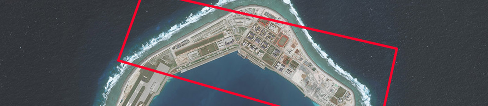
Subi Reef


The aerial imagery of Subi Reef is dated October 10, 2017, and includes close looks at facilities on both the northern and southern arms of the base (but not the majority of the airstrip that runs along its western side). Subi has been of particular concern to Manila because of its location just over 12 nautical miles from the main Philippine-occupied feature of Thitu Island. The facilities apparent in the aerial imagery include:
- Buried storage facilities, presumed to be for fuel, water, or other base necessities.
- A sensor/communications facility topped by a radome.
- Mobile shipping crane used to transfer cargo between ships and dock facility. In the satellite image, it can be seen at the middle of the dock next to several ships, while in the Inquirer photo it is at the eastern end of the dock.
- One of the four point defense facilities built around the base in 2016.
- A large lighthouse.
- The over 3,000-meter airstrip, completed in early 2016.
- Hangar space for 20 combat aircraft, completed by late 2016. Another four such hangars stand at the northern end of the runway.
- Four bigger hangars for large aircraft, completed in early 2017.
- Underground storage tunnels, likely for ammunition and other materiel, built during 2017. Identical buried storage facilities can be found on Fiery Cross and Subi Reefs.
- A high frequency “elephant cage” radar array, so called because the circular construction of the antennae resembles a tall fence.
- One of the four point defense facilities built around the base in 2016.
- Hardened structures with retractable roofs believed to be shelters for mobile missile launchers, completed in 2017. In the Inquirer photo, the top of the radome for the nearby tower, which will presumably be used for targeting, can be seen assembled on the ground, waiting for installation.
Mischief Reef


The aerial photos of Mischief Reef are dated December 30, 2017, and focus on the runway and other facilities along the western side of the outpost. Mischief is the largest of China’s artificial islands and the closest to the Philippines. An arbitral tribunal in 2016 ruled that the reef was entirely underwater prior to China’s reclamation and is therefore a piece of the Philippines’ continental shelf. Facilities visible in the aerial imagery include:
- A large sensor/communications facility topped by a radome, completed in 2017.
- One of the four point defense facilities built around the base in 2016.
- Three towers housing sensor/communications facilities topped by radomes, completed in 2017.
- Underground storage tunnels, likely for ammunition and other materiel, built during 2017. In the Inquirer’s photo, the tunnels are already buried, but AMTI’s satellite image shows the tunnels in an earlier, exposed state. Identical buried storage facilities have been constructed at Fiery Cross and Subi Reefs. There is also more underground storage built along the north side of Mischief (and at Fiery Cross and Subi).
- The base’s 3,000-meter runway, which has been complete since 2016.
- Hangar space for 8 combat aircraft, completed by late 2016.
- One of Mischief’s five hangars for larger aircraft, completed by late 2016.
- A sensor/communications facility topped by a radome paired with what is believed to be an administrative building for the airfield.
- Hangar space for 16 combat aircraft, completed by late 2016.
- An omnidirectional radio beacon for guiding inbound aircraft toward the airfield.
Cuarteron Reef


The aerial images of Cuarteron Reef are somewhat older than all of the other images in the photo set, dating to June 9, 2016. Construction on the smaller four of the seven Spratly outposts appears largely complete, however, so the base looks mostly the same in 2018. Facilities visible include:
- A tall tower housing a sensor/communications facility topped by a radome, completed in early 2016.
- A lighthouse built in 2015, one of the first buildings constructed on the reef.
- One of two point defense emplacements completed in 2016.
- A large administrative building, similar to ones built on Gaven, Hughes, and Johnson Reefs.
- A second point defense emplacement, also completed in 2016.
- A large radar array, likely for high frequency over-the-horizon radar. Because the array consists of a grid of vertical poles, satellite images taken from directly overhead do a poor job of depicting the array. The Inquirer photos thus offer a much more enlightening perspective.
- A communications tower completed in 2015. The two blue radomes on the ground beside the tower in the satellite images do not appear in the aerial photos and were constructed in 2016.
Gaven Reefs


The Inquirer aerial shot of Gaven Reefs was taken on November 28, 2017. Unlike most of the other outposts, all of the point defenses at Gaven are attached to the administrative building, not installed on separate structures. Facilities that can be seen on Gaven Reefs include:
- A solar panel array, constructed in tandem with the administrative building in 2015.
- The headquarters/administrative center on Gaven Reefs, built in 2015. The octagonal structures jutting out from each corner sport gun emplacements, which are covered up in the aerial Inquirer photos.
- A communications tower, with accompanying blue radomes. The tower went up in 2015, followed by the radomes in the first half of 2016.
- Three of six wind turbines on Gaven Reefs (the other three can be seen between the communication tower and administrative building). All six turbines appear to have been erected in 2015.
- A tall tower housing a sensor/communications facility topped by a radome, completed in 2016.
Hughes Reef


The aerial shot of Hughes Reef is also from November 28, 2017. Hughes Reef, like Gaven Reefs, does not have standalone point defense emplacements. The Inquirer photos of Hughes specifically point out one of the gun emplacements jutting off of the administrative building, identifying it as a 100mm/56 caliber gun. Visible facilities include:
- The administrative/headquarters building, constructed in 2015.
- A communications tower with accompanying blue radomes. The tower went up in 2015 and the radomes were installed by the middle of 2016.
- A tall tower with a sensor/communications facility topped by a radome, completed in early 2016.
Johnson Reef


Like Gaven and Hughes Reefs, the aerial photo of Johnson Reef comes from November 28, 2017. The Inquirer shot provides an excellent angle on the point defense emplacement that highlights the staggered heights of each section of the structure and radome, something difficult to discern from satellite images. Facilities visible on Johnson include:
- A point defense emplacement, completed in 2016. The guns on the structure are covered up in the images.
- A communications tower with accompanying blue radomes. As on Cuarteron, Gaven, and Hughes Reefs, the tower was built in 2015 and the radomes completed in 2016.
- A solar panel array built in late 2015 or early 2016.
- Two wind turbines installed in late 2015.
- A tall tower housing a sensor/communications facility topped by a radome, completed in late 2015.
- A large lighthouse.
- The administrative/headquarters building, including point defenses, completed in early 2016.


