In August 2018, the HMS Albion sailed through the Paracel Islands to assert freedom of navigation and challenge China’s claim to straight baselines around the island group. The United Kingdom’s challenge was the first operation by a non-U.S. vessel in the South China Sea that was analogous to the United States’ now well-publicized freedom of navigation operations (FONOPs). Three months later, the USS Chancellorsville undertook an identical challenge to Beijing’s baselines around the Paracels. Similar operations had been undertaken by the USS Decatur in October 2016 and the USS Chafee in October 2017.
The public discussion of South China Sea FONOPs most often focuses on those that take place within 12 nautical miles of disputed features. Those operations are meant either to challenge China’s demand for prior notification for innocent passage through the territorial sea or to assert that there is no territorial sea around naturally submerged banks and reefs. But the steady pace of U.S. and now UK operations challenging China’s declared baselines around the Paracels warrants just as much attention, both because of the egregiousness of that claim and because of a fear that Beijing will soon declare similar baselines around the Spratlys.

Existing Baselines
In 1996, China declared a series of straight baselines around the Paracel Islands from which its territorial sea should be measured. That not only extended Beijing’s territorial sea claim by asserting it should be measured from the grouping as a whole rather than from individual islands; more importantly, it declared all the space within the baselines China’s internal waters. As a result, Beijing insists that foreign vessels have no rights to transit through or fly over the waters between the Paracels, even if they are farther than 12 nautical miles from any individual island. This is the claim that the Albion and numerous U.S. FONOPs have challenged.
The U.S. State Department issued a Limits in the Seas study shortly after that 1996 announcement, detailing its legal objections to the Paracels baselines. The Philippines and Vietnam objected as well. The United States argues that the United Nations Convention on the Law of the Sea (UNCLOS) does not allow a coastal state like China to use straight baselines to connect the islands of an offshore archipelago. That right exists only for archipelagic states, such as the Philippines or Indonesia, whose landmass consists entirely of islands. China must therefore measure the territorial sea and any other maritime entitlements of the Paracels from each individual island, and cannot declare internal waters between them. The United States reiterated this position in a 2016 note verbale to China following Beijing’s response to the South China Sea arbitration award that year.
The arbitral tribunal hearing Manila’s case against Beijing’s South China Sea claims considered the question of whether a coastal state like China might be able to enclose offshore archipelagos (in that case, the Spratlys) with baselines. It found that UNCLOS “excludes the possibility of employing straight baselines in other circumstances [than those expressly listed in the convention], in particular with respect to offshore archipelagos not meeting the criteria for archipelagic baselines.”
But even setting that legal hurdle set aside, UNCLOS still establishes rules that must be followed in setting archipelagic baselines. The two simplest are that the baseline segments cannot, for the most part, be longer than 100 nautical miles, and that the ratio of water to land enclosed by the baselines cannot exceed 9 to 1. China’s baselines around the Paracels meet the first of these. But they far exceed the second limit. Even including all of the new land Beijing created by dredging and landfill in recent years, there is only about 9.11 square kilometers of land in the Paracels. The baselines, meanwhile, enclose some 17,290 square kilometers of water. That is a ratio of 1,898 to 1.
In 2012, Beijing declared straight baselines around the East China Sea’s Senkaku Islands, called the Diaoyu Islands by China. In that case, two sets of baselines were used rather than one, likely to avoid enclosing an even more excessive ratio of water to land than occurred in the Paracels. The Senkakus total about 4.96 square kilometers of land. The combined baselines encompass roughly 153 square kilometers of water. This results in a sea to land ratio of 31:1; much better, but still more than four times the treaty limit.

Modeling Spratly Baselines
China has made no secret of its intention to eventually declare straight baselines around the rest of its claimed features in the South China Sea, including the Spratly Islands. The 1996 baselines declaration ended with, “The Government of the People’s Republic of China will announce the remaining baselines of the territorial sea of the People’s Republic of China at another time.” In its July 2016 White Paper rejecting the South China Sea arbitral ruling, China’s Ministry of Foreign Affairs reiterated that since 1958, its official policy has been to apply straight baselines to the “Dongsha Qundao [Pratas], Xisha Qundao [Paracels], Zhongsha Qundao [Scarborough Shoal and Macclesfield Bank], Nansha Qundao [Spratlys] and all the other islands belonging to China.”
A small number of scholars, almost all from China, have attempted to build a legal case for Beijing to declare baselines around either all or part of the Spratlys. These arguments generally rest on the idea that such baselines should be considered neither straight nor archipelagic baselines governed by the rules of UNCLOS, but rather a sui generis case applicable only to the offshore archipelagos of coastal states. That reasoning is generally dismissed in legal circles outside of China, most comprehensively by J. Ashley Roach. But that has not changed Beijing’s official position on the matter.
The exact nature of baselines in the Spratlys would depend on how brazenly Chinese authorities were willing to flout international law. But the writings of Chinese academics and previous practice in the Paracels and Senkakus suggest four general models.
First, Beijing could decide to ignore all the precepts of UNCLOS and enclose every feature it considers part of the Nansha Qundao within baselines. This would include not only the Spratly Islands, but the entirely underwater Luconia Shoals and James Shoal off Malaysia, as well as Vanguard Bank and other submerged features on the continental shelf of Vietnam. Beijing has consistently ignored the reality that these reefs and banks are underwater, insisting that they are part of the collective whole of the Nansha Qundao. By the same logic, China maintains that the Zhongsha Qundao is a single island group and will one day be enclosed by baselines, despite Macclesfield Bank and the rest of the group except for Scarborough Shoal being underwater. Pursuing this model might enclose about 230,769 square kilometers of ocean within baselines. In contrast, there is only about 17.3 square kilometers of land in the Spratlys by the most generous method of counting (the roughly 4 square kilometers that existed naturally, plus the 13.3 square kilometers created artificially by all parties). That results in a water to land ratio of 13,339:1.

Another possibility is that China could seek to enclose all of the Nansha Qundao but avoid any baseline segments of more than 100 nautical miles. That would still disregard the status of features as high-tide or submerged but would otherwise be consistent with previous practice in the Paracels and Senkakus. The result might enclose about 208,259 square kilometers of ocean for a water to land ratio of 12,038:1.

The first two models would disregard virtually all the rules for establishing straight and archipelagic baselines under UNCLOS. In either case, the treaty requires basepoints to be drawn only to high-tide islands, or low-tide elevations that sit within 12 nautical miles of the coast or another island. A third, marginally more defensible, option would be for China to observe this rule, drawing baselines only around above-water features and nearby low-tide elevations. This would enclose about 122,345 square kilometers of ocean, giving a water to land ratio of 6,494:1.

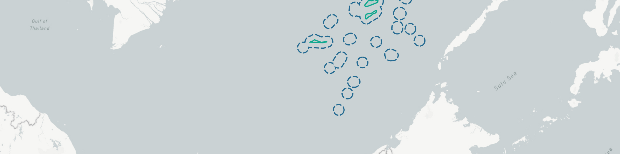
Each of the first three options would amount to Beijing thumbing its nose at the international community and attempting to seal off an enormous section of the South China Sea as internal waters. A less escalatory option, though one that would still be inconsistent with UNCLOS, would be to enclose only closely-grouped high-tide features within baselines. China might argue, for instance, that groups of islets and low-tide elevations which sit on a single contiguous reef or bank should be treated as a collective whole. The six most likely candidates for this treatment would be the features atop Union Banks, Tizard Bank, Loita Bank, Thitu Reefs (including nearby Subi Reef, which is within 12 nautical miles), North Danger Reef, and London Reefs. In this scenario, China would presumably continue to claim territorial seas and other entitlements from the rest of the high-tide features (as well as Mischief Reef, which it has raised artificially) but would not incorporate them within baselines.
The water to land ratios within these hypothetical baselines could vary from 1,838 to 1 for Loaita Bank (with 146.92 square kilometers of ocean to just 0.08 square kilometers of land) to 28 to 1 for Thitu/Subi Reefs (with 142.79 square kilometers of ocean to 5.21 square kilometers of land). Overall these six groups of baselines would enclose 1,923.41 square kilometers of water and 6.99 square kilometers of land for a ratio of 275 to 1.1

One motivation for Beijing to declare baselines around some or all of the Spratlys is to strengthen its claim to an exclusive economic zone (EEZ) and continental shelf from the features. Despite the findings of the arbitral tribunal in 2016, the Chinese government and commentators maintain that the Spratlys are collectively capable of sustaining human habitation or independent economic life, and therefore generate full maritime entitlements. It only makes sense, then, that Beijing would seek to measure those entitlements from a set of baselines drawn around the group. Under any scenario, such a claim to entitlements would cover nearly all of the South China Sea, perhaps even exceeding the limits of the nine-dash line.

In any form, a baselines declaration in the Spratlys would escalate tensions in the region. Claimants like the Philippines and Vietnam would find disputed seas, including those immediately around some of their outposts, suddenly labeled China’s internal waters closed to foreign planes and ships. The United States and other outside parties would also be sure to undertake operations to signal their nonrecognition of those internal waters. And both commercial shipping and airline companies would face the possibility of China attempting to close previous routes through and above these baselines.
Note
1. The others would be Union Banks with 494.63 square kilometers of water and 0.37 square kilometers of land (1,338 to 1), Tizard Bank with 818.31 square kilometers of water and 0.69 square kilometers of land (1,187 to 1), London Reefs with 292.67 square kilometers of water and 0.33 square kilometers of land (888 to 1), and North Danger Reef with 28.09 square kilometers of water and 0.31 square kilometers of land (92 to 1).


