The analysis conducted and conclusions reached in this article are solely those of the author, not of CSIS or the team at AMTI.
Commercially available satellite imagery shows that North Korea has constructed three new piers at the estuary of the Yalu River separating the north-western DPRK from neighboring China. The new docks appear built for barges, which North Korea is currently using to evade sanctions.
Notably, all three facilities appear geared toward shallow bottomed barges rather than ocean going cargo ships, with tracking data provided by the Polestar Global Maritime Domain Awareness (MDA) tool not registering a single visit from a trackable cargo ship to the area since their construction, though several held positions nearby in 2017.
The piers’ completion dovetails with reports that North Korea is increasingly using untraceable barges to move sanctioned cargos across its borders. These vessels typically lack the registration information and identifying features used by investigators to track their more traditional cargo carrying counterparts.
Later satellite images also show that the area has been used to load or unload multiple types of cargo, with heavy activity at two of the sites in late 2019, prior to North Korea’s implementation of strict Covid lockdown measures.
The piers are just a short distance south of Sinuiju Port, a major hub of trade with China that boasts transport access by both land and river routes. That North Korea continued to build and expand these new facilities in the face of mounting sanctions and later Covid restrictions would appear to indicate that Pyongyang forecast a substantial need for additional cargo capacity and throughput in the area.
The new docks also lie within eyeshot of the infamous $250 million bridge project connecting the two countries, which although complete, has remained unused for half a decade.
With a trainline and suspected weapons manufacturing facility nearby, and China just a short distance across the river, the new docks could also provide North Korea with a new vector for moving illicit cargo across its borders via short distance deliveries conducted by difficult to trace barges.
 The location of the new docks at the Yalu River estuary. Image: Google Earth
UPGRADES
Despite international sanctions intended to prevent or limit much of North Korea’s trade, the country has continued to upgrade import and export infrastructure along its coastline. In Nampho, the country’s busiest port, the DPRK’s main oil terminal continues to expand, as does the nearby container handling facility.
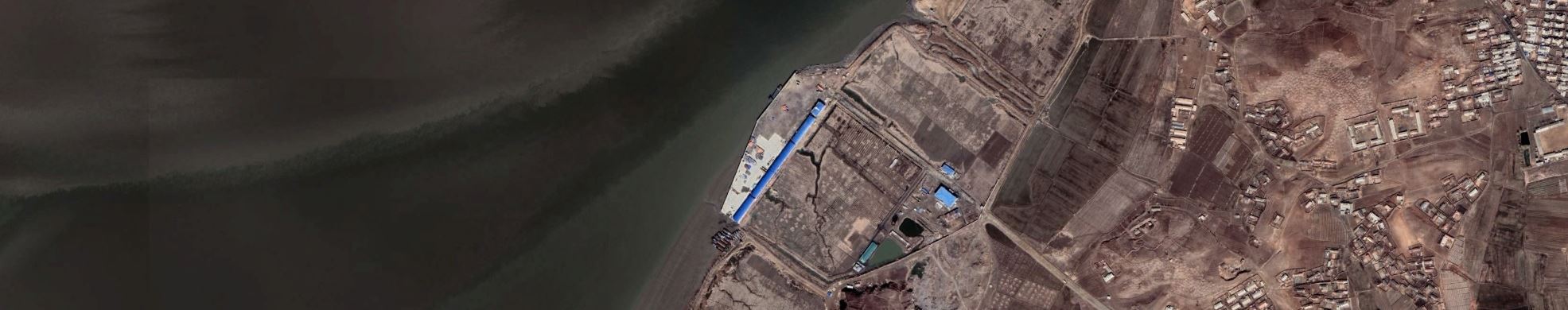
But the new Yalu River piers were built from scratch, with 2016 satellite imagery showing preliminary structures where the southernmost and northernmost piers now stand, approximately 9 miles north from where the river joins the Yellow Sea and around the same distance from China’s bustling Dandong port area.
 The same area before construction started and an image of the southernmost and central piers in March 2021. Image: Google Earth
Construction on the central pier commenced a year later in 2017, with upgrades continuing up until the latest available Google Earth image taken in March this year.
In addition to the piers themselves, North Korea has also constructed accompanying buildings on the docks, with larger buildings also appearing nearby in more recent images. As of March 2021, both the southernmost and central piers appear to have gates and walls in place that prevent direct access from the nearby roads.
 Construction in the area as of March 2021. Image: Google Earth
As of the latest imagery, no permanent loading or unloading infrastructure, like cranes are conveyor belts have been constructed at any of the three piers.
Despite the ongoing work, all three docks were operational and involved in moving cargo from at least 2018. What looks to be small amounts of coal were visible on the southernmost pier in that same year, with various other types of bulk (loose cargo not in bags or containers) also at the site.
 Probable coal spoils and other piled cargos at the dock in 2018. Image Credit: Google Earth
Although it is difficult to tell the exact direction of trade from satellite imagery alone, a subsequent photograph taken in late 2019 shows heavy activity at both the southern and central piers. Trucks are visible moving different types of cargo either to or from the central site and some nearby truck traffic shows both laden and unladen vehicles apparently moving in the direction of the docks.
 White cargo being unloaded / loaded directly onto barges at the central dock in November 2019. Image: Google Earth
Once at the piers, the November 2019 images shows cargo being moved either directly from the trucks onto barges, or by small mobile cranes that are not present in later images. Most of the visible cargo comprises white bags, though the image also shows wooden crates being moved at the southernmost pier. One of the nearby trucks in the same image approaching the southern dock also appears to be carrying similar crates.
 Crates being loaded or unloaded on the southern dock in November 2019. Image: Google Earth
Later images taken in 2020 show less activity at the site, likely coinciding with North Korea’s more general reticence to trade internationally during the pandemic, though barges continued to move some cargo to the southernmost pier throughout the year. Construction work on the nearby buildings also continued.
The latest image taken in March 2021 shows all three piers apparently operational, but with new building construction ongoing on both the northernmost and central piers.
BARGE OVER THE RIVER YALU
The construction of the new piers at the Yalu River estuary appears to provide North Korea with new capabilities that could be used for legitimate trade, but that also offer clear benefits for sanctions-evading smuggling.
On the one hand, the new piers might cut transit time to Sinuiju from Dandong or other nearby Chinese ports and provide easier trading during frozen winters. And given they are located in shallow waters, it is not surprising that regular cargo ships with deeper draughts do not visit the new facility.
Yet the advantages for North Korea’s new preferred method of smuggling cargo also seem clear. In their most recent report, the UN Panel of Experts (PoE) noted how North Korea was now using these types of vessels to move vehicles and other sanctioned cargo, in addition to helping smuggle hundreds of thousands of tons of sanctioned coal.
Never intended for international travel, these small vessels are not registered in maritime databases, making tracking down associated ownership and management challenging, and undercutting the ability of regulators and investigators to locate the origins of possible sanctions breaches and the foreign networks that enable them.
The new docks could allow for barges to more readily deliver or pick up sanctioned cargo—and the timing of their completion matches Pyongyang’s pivot to this relatively new evasion method. They may also allow barges to transfer cargo without heading deeper into North Korean waters to Sinuiju, away from prying eyes and photographers on the Chinese side of the river, who populate open-source photography databases like Flickr with telephoto shots of the North Korean bank and docks.
As expected, the Pole Star vessel tracking platform records relatively few tracking signals at the new docks. This contrasts with the Chinese side of the river where hundreds of barges are also visible and which appears to be a hive of automatic identification system (AIS) tracking activity. This indicates that signal coverage in the area is good, but that vessels visiting the North Korean side do not have or do not use tracking equipment.
![]() A snapshot of AIS tracking signals gathered over the last six months, with China on the left and North Korea on the right of the Yalu River. Image courtesy of Pole Star Space Applications.
A snapshot of AIS tracking signals gathered over the last six months, with China on the left and North Korea on the right of the Yalu River. Image courtesy of Pole Star Space Applications.
But AIS signals are not totally absent from the North Korean dock area, with the Pole Star platform occasionally picking up signals lacking the unique identifiers associated with ocean going cargo ships. These signals indicate the presence of barges and usually broadcast that they are flying a Chinese flag, an AIS signature by now familiar to investigators and sanctions enforcement bodies. At minimum, the signals indicate that the docks are being used for some type of international trade and are not solely intended to facilitate moving goods along the DPRK’s coastline.
This scenario opens questions as to why North Korea would construct these new docks for international operations when it had serviceable facilities just a short distance northward, complete with a well-established customs infrastructure that no doubt already handles large volumes of trade from China.
The new docks are just 9 miles from the Pukchong Machine Complex, and a rail line from a nearby freight depot runs parallel to the docks and connects directly to the facility. In the late 2019 satellite image, trucks similar to those seen on the docks are also visible at the freight depot.
According to the Nuclear Threat Initiative, Pukchong may have “provided parts or components used in the manufacturing of TELs (Transport Erector Launchers) and MELs (Missile Ejection Launchers), as well as machines used at missile production plants.”
And while it is unwise to infer too much from satellite imagery and vessel data alone, North Korea has proven time and again that it is wholly committed to evading UN sanctions regimes and circumventing new sets of restrictions more quickly than they can be issued, no doubt acquiring large amounts of resources in the process. Within the context of such a dedicated and well-oiled sanctions evasion machine, a new set of docks might represent just a small, new cog.