Survey vessels have become important actors in China’s efforts to assert its maritime claims in the South China Sea. Since 2019, China has deployed survey ships four times in direct response to Southeast Asian oil and gas activity as part of widely reported standoffs. But China also conducts a significant number of surveys in the South China Sea that don’t make headlines. Automatic identification system (AIS) data on Chinese surveys from 2020 and 2021 demonstrates that China’s survey activities span the entire South China Sea and regularly occur in the exclusive economic zones (EEZs) of its Southeast Asian neighbors. Such surveys for marine scientific research or oil and gas exploration without permission are illegal under international law; those for purely military research are legal but run counter to China’s stated opposition to foreign military surveys within the EEZ.
Targeted Surveys
Survey ships have become part of a standard response by China to Southeast Asian oil and gas activity. From July through October 2019, the state-owned Haiyang Dizhi 8 conducted survey operations in Vietnam’s EEZ in response to new Vietnamese drilling in Block 06-01 near Vanguard Bank. It was escorted by the China Coast Guard and militia and conducted its survey while other law enforcement and militia vessels harassed the Vietnamese drilling operations. This playbook would be repeated again in the spring of 2020 when the Haiyang Dizhi 8 conducted a survey off Malaysia in response to exploratory drilling in Malaysia’s ND-1 and ND-2 blocks. In fall of 2021, China upped the ante by conducting two surveys simultaneously, one by the Haiyang Dizhi 10 in Indonesia’s EEZ, and one by the Da Yang Hao in Malaysia’s, again conducted in response to new oil and gas activity.

The immediate impact and apparent intention of these surveys is to demonstrate Chinese control over waters it claims as its own. The survey path of the Haiyang Dizhi 10 becomes particularly significant in this regard, as it clearly traces the overlap of Indonesia’s continental shelf claim and China’s nine-dash line. This runs counter to Chinese attempts to downplay the nine-dash line in favor of the “Four Shas” as the basis of its maritime claims since 2016.
Aside from their symbolic goals, these surveys also produce data on seabed conditions that hold value for both civilian and military purposes. While seismic data is critical in assessing geological conditions and the presence of hydrocarbons, water and seabed conditions also affect the ability to detect submarines. And research vessels purportedly involved in scientific research can also use their instruments for naval reconnaissance, gathering intelligence on foreign military facilities and vessels.
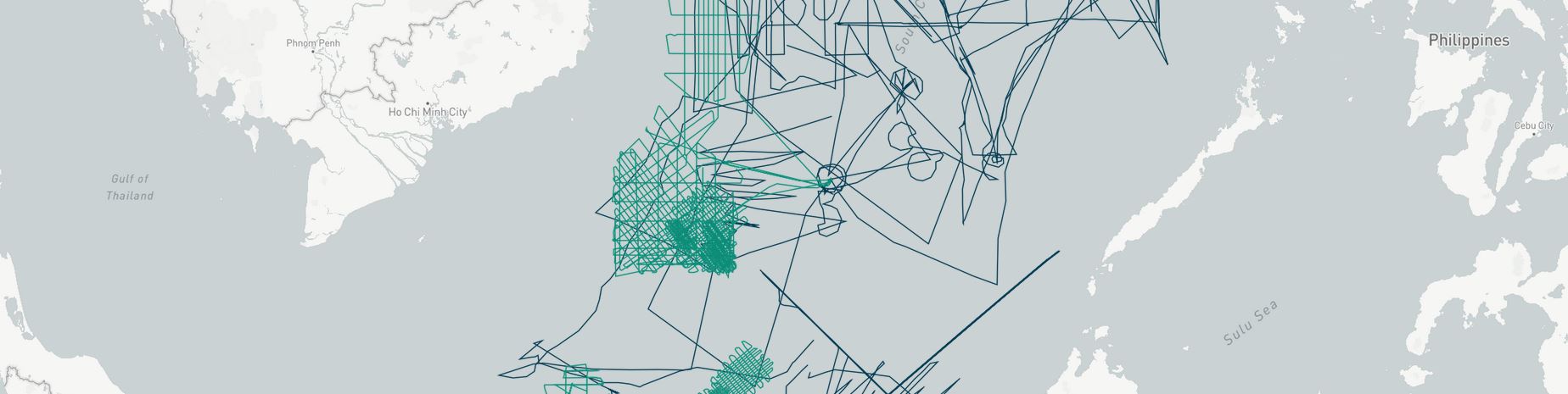
Other Surveys
To gain a better understanding of the scope of Chinese survey activities in the South China Sea, AMTI mapped historical AIS data from commercial provider Marine Traffic and the Vietnam-based South China Sea Chronicle Initiative, which monitors and issues regular updates on Chinese survey activities.

This data is not exhaustive, and the true extent of Chinese survey activities during this period is likely greater than this map would indicate. The number and extent of surveys conducted underscores the rapid growth and development of China’s survey fleet, the largest and most active in the Indo-Pacific. It is impossible to determine what type of research these vessels were conducting based on AIS alone. These surveys did not follow the grid or “lawnmower” pattern typical of bathymetric and seismic surveys, as seen in three of the four surveys discussed above in retaliation for Southeast Asian oil and gas activity.
The purpose of a survey, whether commercial, scientific, or military, is important for determining its legality. The survey activities of ships flagged to other nations can usually be distinguished by the vessel’s operator. In the United States, for example, military surveys are done by the U.S. Navy, marine scientific research is conducted by universities or civilian organizations like the National Oceanic and Atmospheric Administration, and commercial surveys are conducted by private companies. But the lack of such distinctions among China’s state-owned fleet makes it impossible to confidently identify the purpose of most surveys. China’s pursuit of civil-military integration makes it likely that data obtained by Chinese survey vessels is shared among scientific, military, and commercial entities.
Explore the full dataset of Chinese surveys in the South China Sea below:


