Marine research vessels have been making waves in the Indo-Pacific recently. This is especially true of China’s large fleet. State-owned Chinese vessels have engaged in oil and gas surveys on the continental shelves of its neighbors, as the Haiyang Dizhi 8 did off the coast of Vietnam for four months last year. Others have conducted marine scientific research without the permission of coastal states. This was the case with the Shiyan 1, which India expelled from its exclusive economic zone (EEZ) near the Andaman and Nicobar Islands in September 2019, and the Zhang Jian, whose operations in the Philippine EEZ last summer drove President Rodrigo Duterte to hastily declare a ban on all foreign research vessels in his country’s waters.
Such research can serve both civilian and military purposes. Oceanographic data is crucial for undersea operations, as water and seabed conditions affect the ability to detect submarines. Research vessels purportedly involved in scientific research can also use their instruments for naval reconnaissance, gathering intelligence on foreign military facilities and vessels. Australian defense officials reportedly described an early 2020 survey by China’s Xiang Yang Hong 01 near Christmas Island as intended to study the routes of Australian submarines traveling to and from the South China Sea.
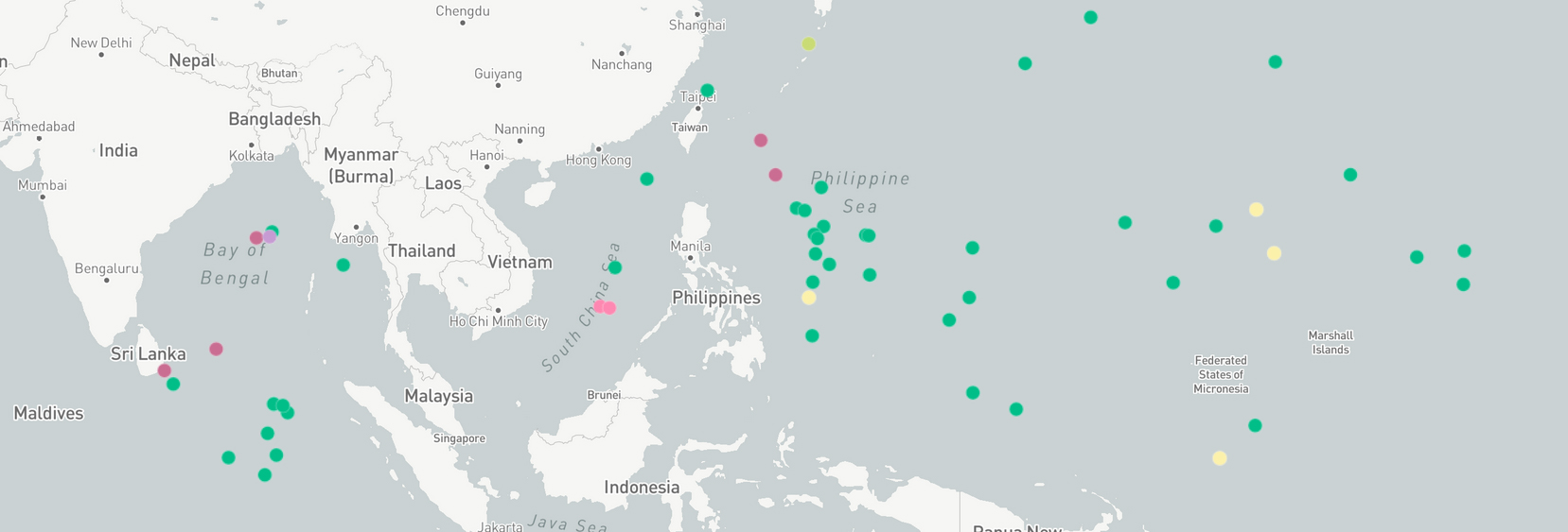
To better understand the scale of such research activity in the Indo-Pacific, AMTI tracked state-owned or -operated survey vessels in waters beyond their government’s legal jurisdiction over the last year. The data confirms that China operated by far the largest fleet of government research vessels in the region. This analysis relies on the automatic identification system (AIS) signals broadcast by these ships and collected on the commercial platform Marine Traffic. The data is necessarily incomplete because it does not include all naval surveillance activities, including those of the United States. Military vessels are not required to broadcast AIS under the International Maritime Organization’s Safety of Life at Sea Convention.
The interactive map below shows the location of each research activity undertaken by these vessels across the Indo-Pacific last year. AMTI determined when a ship was engaged in research based on its course and speed as revealed by AIS. The most recognizable behavior is that of ships operating in a grid or “lawnmower pattern,” which indicates a bathymetric survey to map the seafloor. A vessel transiting at low speed for a sustained period is a sign that it is collecting data, for instance with a towed instrument array. Other indicators of research activity include a vessel stopping at regular intervals or revisiting the same spot repeatedly, which suggests that it is taking measurements or deploying equipment. This is not meant to be an exhaustive list; some research occurs without leaving clear evidence in a ship’s course and speed. Nonetheless, the map provides a good sense of where and how often each government is conducting research outside its own waters.
The terms “research vessel” and “survey vessel” are commonly used for ships engaged in three types of activity: marine scientific research, naval surveillance, and commercial surveys, especially for oil and gas. Each of these activities is governed differently under international law, which makes it very important that coastal states be able to distinguish which a ship is undertaking.
The United Nations Convention on the Law of the Sea (UNCLOS) requires governments to seek permission at least six months in advance for marine scientific research in another state’s EEZ or continental shelf. Coastal states are expected to provide that consent with a few exceptions. These include if the coastal state suspects that research is commercial in nature, if it involves drilling into the continental shelf, or if the requesting state provides inaccurate information. All states are free to conduct marine scientific research in international waters.
Naval research and surveillance is not clearly regulated by UNCLOS. Most countries, including the United States, maintain that there are no restrictions on the right to conduct military surveys within the EEZs of other states. But China and several others in the Indo-Pacific claim the right to block foreign military activities within their EEZs.
Commercial surveys within the EEZ or on the continental shelf must have the coastal state’s permission. In areas beyond the continental shelf, commercial seabed rights are regulated by the International Seabed Authority.
It is usually possible to determine which category of research a vessel is undertaking based on its ownership and designation. In the U.S. case, the Navy operates a fleet of research ships dedicated to military surveys. At least seven of these ships operated in the region over the past year, though much of their research likely occurred when they were not transmitting AIS. Publicly funded marine scientific research, by contrast, is undertaken by civilian agencies like the National Oceanic and Atmospheric Administration and National Science Foundation, or by government vessels leased to public universities. Commercial surveys are left to the private sector.

Most countries maintain a similar distinction between naval survey ships, vessels engaged in marine scientific research, and ships involved in commercial operations. But China does not. The People’s Liberation Army Navy (PLAN) has some research ships of its own, but it also relies heavily on the work of ships controlled by other agencies, mostly under the Ministry of Natural Resources, that conduct both military and civilian marine scientific research. A different set of institutions originating from the former Ministry of Land and Resources conduct commercial surveys of mineral resources, but they also have formal cooperation with the PLAN and presumably share scientifically and militarily relevant data with other departments. The reverse is also likely true when other agencies collect data of commercial value.
The Xiang Yang Hong 01 is a case in point. It is one of a fleet of vessels transferred to the new Ministry of Natural Resources from the State Oceanic Administration when the latter was disbanded in 2018. As noted above, Australian authorities believe the ship was conducting military surveys when operating in international waters between the Australian mainland and Christmas Island in early 2020. It conducted similar surveys in the eastern Indian Ocean—an area frequented by numerous Chinese survey ships over the last year—and in the western Pacific Ocean. The latter included part of the EEZs of Papua New Guinea and the Federated States of Micronesia. Understanding the bathymetry in these areas is critical if Chinese submarines hope to effectively operate beyond the “first island chain” surrounding China’s near waters.

The Xiang Yang Hong 01’s sister ships undertake similar surveys that at times appear military rather than civilian in nature. In June 2019, the Xiang Yang Hong 03 circled within 30 nautical miles of the U.S. territories of Guam and the Northern Mariana Islands before conducting a bathymetric survey in waters that included part of the U.S. EEZ. A few months later, the ship appeared to conduct research near Hawaii, approaching in a straight line to within 75 nautical miles of the U.S. state before doubling back on its course.

Aside from China and the United States, Japan was the only country whose research vessels operated across the entire Indo-Pacific over the last year. But Tokyo clearly distinguishes between marine scientific research vessels overseen by civilian agencies and military survey ships controlled by the Self-Defense Forces. For instance, the Japan Meteorological Agency’s Keifu Maru conducted research cruises along several meridians in the Pacific over the last year, traversing both international waters and coastal EEZs. The agency has been observing ocean conditions along one of these—the 137th degree of eastern longitude—annually since 1967. Its ships stop at set intervals to collect data including temperature, salinity, oxygen, and nutrient levels at different depths.

Compared to other players in the region, Southeast Asian governments operate relatively few research vessels. And most of those confined their activities to their own waters over the last year, with one notable exception. In May 2019, the Philippine military’s Hydrographer Presbitero was reported to be conducting research near Thitu Island, the Philippines’ largest occupied feature in the Spratly Islands and the site of persistent patrols by Chinese vessels from nearby Subi Reef. AIS shows that the ship also undertook an apparent seabed survey across a large area near Philippine-occupied West York Island. Most of this research took place within the Philippine EEZ or the territorial seas of contested rocks, but some of it included international waters (according to the 2016 ruling in the Philippines vs China arbitration).

The prevalence of marine research vessels across the Indo-Pacific is neither surprising nor in most cases problematic. But the confusion and potential violations of international law involving much of China’s fleet is different. In many cases, including those referenced above in Indian, Philippine, and U.S. waters, China did not secure the necessary permission of coastal states to conduct marine scientific research in their EEZs. The most likely explanation is that the surveys were military in nature and therefore not governed by UNCLOS. If so, this suggests a double standard in which Beijing demands that other states seek permission for military surveys in its EEZ while not requiring its vessels to do the same abroad. But it is also problematic that these surveys are being conducted by civilian agencies. It makes it impossible for a coastal state to know whether a Chinese survey vessel operating in its EEZ without permission is undertaking legal military surveillance, illegal marine scientific research, or even commercial surveys.


